A Guide to the Best Hikes in Ireland
Ireland is famous around the world for its luscious green fields, friendly welcome and of course our cosy pubs! Despite these traditional assumptions, we are fast becoming one of the world’s leading destinations for outdoor adventures and hiking, due to our rugged and wild landscapes that are relatively safe all year round, providing you have the right outdoor clothing and hiking equipment!
With the longer evenings here and hopefully some warmer weather, it’s the perfect time to get out and discover the great outdoors on your own doorstep, if it’s hiking or walks! If you are a seasoned pro or a sunshine hiker, we’ve got a guide to some of the best Ireland hikes for everyone, from the Bray to Greystone’s walk, there is an outdoor adventure to suit everyone.
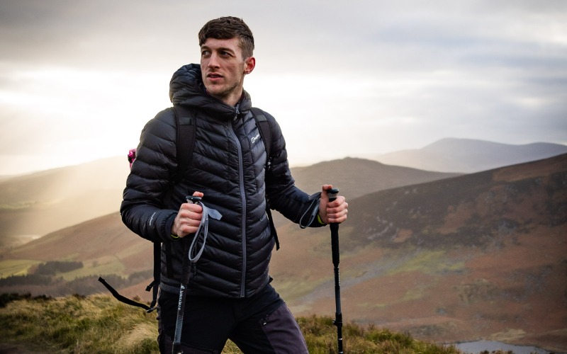
Ensuring you have the correct outdoor clothing, footwear and hiking equipment is essential before you head off on your adventure. O’Neills have a wide range of outdoor clothing, walking boots and hiking equipment from top brands such as Columbia, Trespass and Berghaus. Protect yourself from the elements with a waterproof outdoor jacket, ensure your hiking boots offer the correct level of support and grip, use trekking poles to steady yourself on uneven ground and carry a rucksack to store your essentials.
We recently teamed up with Irish outdoor enthusiasts Tony Smith and Gareth Laheen on a hike, check out the video here.
Best Hikes and Walks in Ulster
Slieve Donard, County Down
Slieve Donard is situated on the coast of County Down amongst the Mourne Mountains and is the highest mountain in the North of Ireland, standing 850 meters high and 4.6 kilometers long (9.2km in total). Depending on your pace and the weather, it can take between 4-5 hours to complete. The hike is graded moderate to strenuous but the views from the top of Donard make the hike up worth it, we promise! On a clear day you can see as far as Belfast & Dublin along with spectacular views of the Mourne Mountains.
The most popular route up Slieve Donard is The Glen River Route. The starting point for this route is at Donard Carpark in Newcastle. Start the hike by following the defined path through Donard Forrest Park. The path through the forest runs alongside the Glen River, which you will cross a couple times before you reach a saddle between Slieve Commedagh and Slieve Donard. Continue down this route which is a well paved path until you reach a bridge to cross the river before you reach the famous Mourne Wall. The Mourne Wall will guide you straight to the top however, the next section of the hike is a steep with few false peaks before the summit.
If you need any hiking gear or outdoor clothing, you can always visit us in our Newry and Craigavon stores which are located nearby.
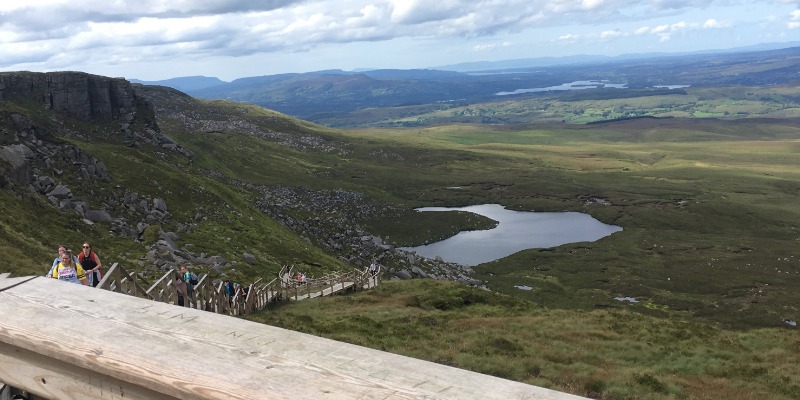
The Stairway to Heaven – Cuilcagh Boardwalk Trail, County Fermanagh
The Stairway to Heaven is a walk based in County Fermanagh that is part of the Marble Arch Caves Geopark. This walk takes around 3 hours to complete with an elevation gain of 550 meters. The hike is graded as difficult & a moderate level of fitness is required. Depending on where you start your hike from, the hike is between 9km-11km.
The Stairway to Heaven is a gradual climb that crosses a blanket of bog before you reach the steep incline of wooden steps to reach the summit. Once at the summit there is a wooden viewing deck that is perfect to sit back and take in the 360° views of Cuilcagh mountain and the boardwalk that snakes down across the bogland.
The Stairway to Heaven is accessible from two different carparks that act as starting points. The first carpark is free & brings the hike up to a total of 11km return. The second carpark is the closest to the trail head in which you must pay for, from this carpark the hike is a total of 9km. This trail is well signed posted making it almost impossible to get lost. For the first 3km of this hike you will follow a gravel path that leads you to the boardwalk section of the hike. The boardwalk section continues for another 3km with a gradual incline and a few steps. This section will lead you to the ‘Stairway to Heaven’ section of the hike where you will complete a total of 450 wooden steps to reach the summit. This part of the hike can be difficult however, the views at the top are worth it.
Mount Errigal - County Donegal
If you’re looking for some of the best hiking in Donegal than look no further than Mount Errigal. There are many options for walks in Donegal but to stand on top of Errigal might give you a sense that you’re on top of the world.
Located in the Derryveagh Mountains, Mount Errigal stands at a height of 751m. This is graded a moderate to strenuous hike. It is approximately a 4.5km total hike that takes roughly anywhere from 1.5-3 hours to complete depending on your fitness levels and how long you want to spend at the top taking in the views of the vast 7 sisters mountain range and the wild Atlantic Ocean.
The hike up Errigal starts from the carpark located at the foot of the mountain along the main road. From here you follow the well-worn path from previous hikers up the mountain on the right side of the river. This path takes you across boggy land before you reach the scree. The scree section gets steep quickly and can be loose underfoot which may make footing tricky at times so having the right hiking boots and some trekking poles are a must. The path continues up the mountain and gets narrow as you make your way closer to the top. Upon reaching the summit you’ll find two peaks – the first one marks the highest point on Errigal. The second peak is worth crossing over to soak in the views for those brave enough to cross the ‘one man’s path’ that joins the two peaks.
Best Hikes and Walks in Leinster
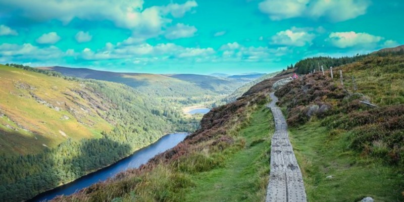
The Spinc, Glendalough – County, Wicklow
The Spinc is amongst the most popular hikes in Ireland and is part of the famed Wicklow Way. It is easy to see why with its breathtaking views of Glendalough Lake. The Spinc ‘White’ loop trail is just shy of 10km and takes 3.5 hours to complete. It reaches a height of 410m and is regarded as a strenuous hike.
Start the hike from the upper car park at Glendalough where the trail begins. This is a well signposted hike and if we’re honest probably amongst the most popular hikes in Ireland. From the carpark follow the signposts for the ‘white’ trail making your way towards Poulanass Waterfall. Once you have passed Poulanass waterfall continue the path until you reach the boardwalk. The boardwalk then continues around to the viewpoints overlooking the upper lake providing the best views of Glendalough. The boardwalk continues around the top of the cliffs before descending towards a rocky trail known as ‘The Miners Village’ before returning onto a good gravel trail that brings you back around to your starting point at the car park.
Wicklow itself has many different walks throughout the county, with the Bray to Greystones walk a popular choice for many.
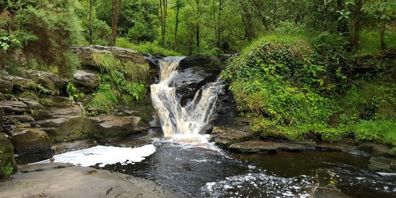
Glenbarrow Eco Walk, Slieve Bloom – County Offaly
The Glenbarrow Eco Walk is known for its waterfalls, glens and tranquillity. It is 8.5km long and takes roughly around 2.5-3 hours to complete. There is a slight elevation gain of 100m and this hike is graded as moderate, so leave your walking boots at home and get your walking jacket on instead!
The hike starts at the Glenbarrow Trailhead where a signpost details three different trail options. Follow the orange arrows that lead down a narrow mossy path to start the hike. Beside this path flows the great River Barrow, Ireland's second-largest river. The path leads you up a gradual hill towards the Glenbarrow waterfall. Once you reach the waterfall, continue upstream until you reach a 19th century farmstead. Continue from the farmstead following the signs for the Ridge of Capard where you will be greeted with 360° views of Offaly. You can stay on the trail following the wooden boardwalk which eventually leads you to an entrance to Capard Woods. Follow the path down the woods to an abandoned quarry where you can enjoy spectacular views of Croghan Hill.
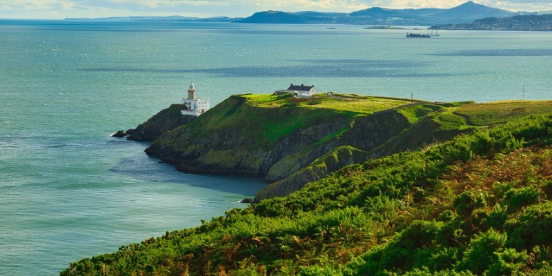
Howth Summit walk, Co. Dublin
One of the most popular walks in Dublin has to be the Howth Summit walk, a short distance from Dublin City Centre that is accessible via the DART. You can leave your hiking shoes and hiking socks at home for this one, a good walking jacket (preferably waterproof) is all you will need.
The looped walk around the headlands begins at Howth DART station, follow the green arrow along the promenade and then turn right onto the cliff path. The walk takes you up to the top before looping down again. There are other, longer walks marked by blue, red and purple arrows. This walk will give you incredible views of Dublin Bay but expect it to be crowded at weekends.
Best Hikes and Walks in Connacht
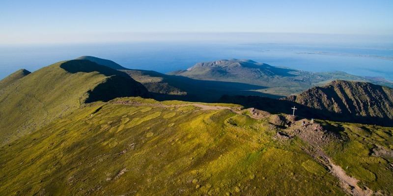
Croagh Patrick
Known locally as ‘The Reek,’ Croagh Patrick has been a pilgrimage route since ancient times. This impressive mountain overlooks the town of Westport, Clew Bay and the hundreds of islands in the bay and is of course famous for its connection to our Patron saint, St Patrick.
The main trail up Croagh Patrick ascends the mountain from the signed car park in the west end of Murrisk. The steep trail is rocky in parts, and it gets crowded on sunny weekends. At the summit, you'll find a 1905 whitewashed church and a 9th-century oratory fountain. The views are sublime. Walkers are advised not to use the traditional Pilgrim’s Path due to high levels of erosion. Some people do this hike in their bare feet, so no need for the hiking socks and hiking boots if that’s for you, but a hiking pole might come in handy for the steep slopes!
The hike is approximately a 7km hike taking up to four hours or more.
Kilcornan Woodland, County Galway
Looking for a scenic walk in Galway? If you’re on a city break with the family and looking to get some fresh air close to the city, then Kilcornan Woodland is for you.
A wild forest, the walkway running through the middle is paved, making it easy to navigate with wheelchairs and buggies. You can also go off the path with nearby forest trail routes. It’s near impossible to get lost, making it a pleasant afternoon stroll for families.
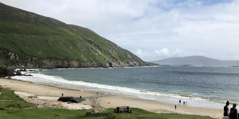
Achill, Co. Mayo
Despite being connected to the mainland since the 1880s, it still has an island feel and much of the landscape is pure rugged unspoilt beauty, the same way it was centuries ago. The walks here vary from the top of sea cliffs to gentle strolls through undulating deserted villages. The Slievemore loop climbs to a height of 197ft and travels through a deserted village as well as an ancient graveyard and megalithic tomb. It's a moderate hike which is approximately 5km, starting and finishing at the base of Slievemore mountain.
If you’re feeling more adventurous, a hike out around Achill Head located on the western tip of Achill Island takes you along some of Europe’s highest sea cliffs, but this strenuous walk is not for the faint-hearted and should be approached with caution. While hiking along some of the highest cliffs in Ireland you’ll explore old signal towers, follow steep headlands, and keep an eye out for peregrine falcons. You’ll walk along headlands doused in other-worldly mist – and get stunning views with a distant sense of being on the edge of the world.
Best Hikes and Walks in Munster
Carrauntoohil, Co. Kerry
Carrauntoohil is the country's highest summit, at 1040m and is one of the 27 peaks in the Macgillycuddy’s Reeks. There are a few routes to the top, but even the most straightforward requires good hillwalking and navigation skills, while others are serious scrambling or rock-climbing routes. If you don’t have good map-reading and compass skills or are even slightly unsure, please hire a guide. If you do decide to take on the hike you will experience an area that is full of lakes, forests, and spectacular views so you won’t be short on places to explore.
It’s a challenge of a hike, but worth it. Not only are the views from the summit some of the best and highest in Ireland, but the trail around the mountain itself is stunning. Depending on the weather conditions, there are a few paths to the summit: Devil’s Ladder, O’Shea’s Gully, or the Caher Route. We’ve said it already, but even the most straightforward requires good hillwalking and navigation skills, so plan accordingly before taking this hike.
Approximately a 12KM hike to the summit.
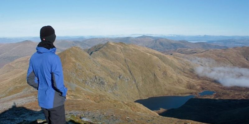
Photo credit Nick Bramhall
Mount Brandon, Co. Kerry
The highest peak on the Dingle Peninsula has rugged trails with jaw-dropping spectacular views. Mt Brandon itself is deemed a sacred mountain that allegedly takes its name from St. Brendan the Navigator. It is believed that St Brendan spent 40 days on the mountain preparing for his journey to America which he supposedly saw from the summit during his climb.
Mount Brandon stands in impressive isolation to the north of Dingle, a difficult ridge bounded by remarkable cliffs and glacial lakes and falling steeply into the sea to the northwest. In clear weather the views are stupendous, you won’t see America, but you will get beautiful views over southwest Ireland!
There are different routes between 9 and 15km depending on which you take, park at the Faha Grotto.
The question is, which hike will you take on? It may be a tough climb to the top of a summit, but the views are always worth it on the Emerald Isle. Remember to prepare for your hike accordingly with the correct outdoor clothing, walking boots, hiking equipment and directions.


